Day 3; Wednesday,
August 14
 The next morning it was cold and miserably overcast when we got up at 05.45.
However, we breakfasted on bacon and the last of our eggs, and were away by
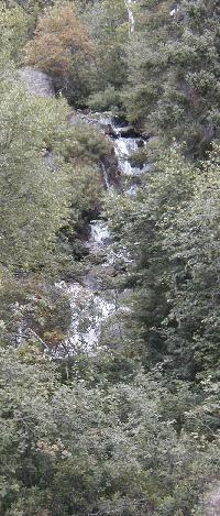
08.00. We paddled over to the shore to see the two waterfalls. These falls take
the outflow from Palmer Lake at +406 m to Buchner at +371 m, a 35 m drop over
the rocks. The hard granite rock shows no sign of erosion since the ice age
ended 10,000 years ago.
The next morning it was cold and miserably overcast when we got up at 05.45.
However, we breakfasted on bacon and the last of our eggs, and were away by
08.00. We paddled over to the shore to see the two waterfalls. These falls take
the outflow from Palmer Lake at +406 m to Buchner at +371 m, a 35 m drop over
the rocks. The hard granite rock shows no sign of erosion since the ice age
ended 10,000 years ago.
The narrow outlet from Buchner Lake to the north end of Kemp Lake (nominally one metre lower) was blocked by several beaver dams, which we stood on and pulled the canoes over. The size and engineering of a beaver dam is always a surprise.
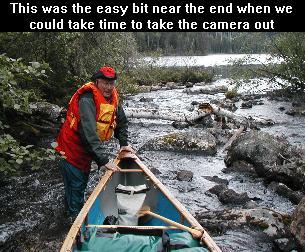 Below the dams there was supposed to be a portage: the
portage can be seen on the right, or west, bank just above a shallow rocky
rapid. Although we had the grid reference and searched we did not find any
portage so we walked the canoe down the rocks. Just in front of Peter you can
see a fallen Birch tree. This gave Brent pause for thought since
(a) He was quite nervous
because he thought Peter
might get pinned
Below the dams there was supposed to be a portage: the
portage can be seen on the right, or west, bank just above a shallow rocky
rapid. Although we had the grid reference and searched we did not find any
portage so we walked the canoe down the rocks. Just in front of Peter you can
see a fallen Birch tree. This gave Brent pause for thought since
(a) He was quite nervous
because he thought Peter
might get pinned
 We continued south and southwest on Kemp Lake, under very
dark skies but traveling fast with a following wind. According to the guide:
We continued south and southwest on Kemp Lake, under very
dark skies but traveling fast with a following wind. According to the guide:
The small river connecting Kemp Lake to the northeast
corner of Hood Lake is fast-flowing and shallow. Upon leaving Kemp Lake there
are three small rapids very close together. Water conditions will determine
whether or not the canoeists line down the first two. The third, which has a
number of sharp ledges has a well-used portage on the north, or right, shore to
a pool below. From the foot of this portage, a channel has been cleared in the
river enabling canoes to be paddled and lined approximately 550 metres (601
yards) down to quiet waters below. The river channel opens into a small bay on
the northeast end of Hood Lake.
Initially we dragged the canoe over three beaver dams, but again, we found no
sign of portage P15, so we continued, walking, paddling in short bursts, and lining
and stumbling down the 2 km stream. The stream was flowing fast,
definitely
There was no ‘cleared channel’ either. The small bay had evolved into a reedy marsh for 500 meters until we got to clear water on Hood Lake.
A bit weary, and wet from that passage we stopped for lunch
on a flat rock at GR 410661. The temperature was still the same 10°C (50°F) as when we
got up, and the northerly wind blowing hard and spitting rain. We did not build
a fire but cooked some soup on Warren’s tiny gasoline stove. This took some
time as we did not know how to set up the stove and initially we had it upside
down. Eventually we had a spectacular priming flame and the stove lit OK.
 We re-embarked and continued south on Hood Lake, in the wind and rain but at
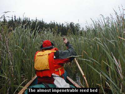
least at our backs. The guide says: The narrow stream channel connecting the
south end of Hood Lake to the north end of Satkowy Lake is navigable. It may
have been navigable at one time, but presently it consists of about 400 m of
dense, tall and thick reeds. We looked for water flow (Sotkowy Lake is nominally
2 meters higher than Hood but the water flow does not suggest such a difference)
but could not see much of significance, so we pushed into the thinnest part of
the reeds, occasionally standing up to look for patches of open water and trying
to avoid the cranberry bushes in the bog. The passage was very difficult. Our
paddles did not reach the bottom, so we could not contemplate walking. We had to
lean our paddles back against the root mass of the reeds near the surface and
simultaneously heave to advance a few centimeters. Sometimes we abandoned the
paddles and advanced by pulling on handfuls of reeds. It was touch and go
whether we made it, but there was no going back. By the time we finished we were
dripping with sweat.
We re-embarked and continued south on Hood Lake, in the wind and rain but at
least at our backs. The guide says: The narrow stream channel connecting the
south end of Hood Lake to the north end of Satkowy Lake is navigable. It may
have been navigable at one time, but presently it consists of about 400 m of
dense, tall and thick reeds. We looked for water flow (Sotkowy Lake is nominally
2 meters higher than Hood but the water flow does not suggest such a difference)
but could not see much of significance, so we pushed into the thinnest part of
the reeds, occasionally standing up to look for patches of open water and trying
to avoid the cranberry bushes in the bog. The passage was very difficult. Our
paddles did not reach the bottom, so we could not contemplate walking. We had to
lean our paddles back against the root mass of the reeds near the surface and
simultaneously heave to advance a few centimeters. Sometimes we abandoned the
paddles and advanced by pulling on handfuls of reeds. It was touch and go
whether we made it, but there was no going back. By the time we finished we were
dripping with sweat.
It was just over a kilometre to P16. This one was formidable: The canoe route leaves Satkowy Lake over a winter road portage to the north end of Guncoat Bay of Mountain Lake. Approximately 760 metres long and in good condition. It was not in what we would call good condition The start was 30 metres of bog, and the rest, although wide, had lots of muskeg and water running down the trail. However, it was generally downhill in the loaded direction (Guncoat Bay at +339.9 is 25 metres lower than the +365 of Sotkowy.) Just after the start we began to see fresh footprints on the trail, but these prints had toes! Then we began to see squirts of blueberry detritus, so we stuck together and began counting our steps in loud voices. The trail also proved to be somewhat longer than 760 metres, perhaps because the end had been extended to avoid a reed bed at the head of Guncoat Bay. Guncoat Bay is part of Mountain Lake on the Churchill River system, so we had flat water for most of the remainder of the trip.
We decided that after our efforts we deserved an early camp, particularly as
we were well up on our trip schedule, so we immediately began looking for a site
on the islands in Guncoat Bay. We saw two pelicans sitting on a rock and took
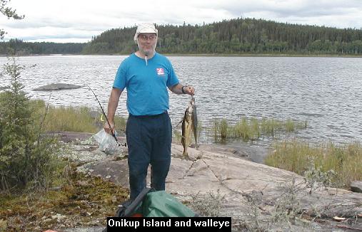
that to mean that the fishing was good. On rounding the north of Onikup Island
we found a campsite on the NE corner at GR 400593. The
campsite was okay but there really was only room for
At this stop, we spread out our maps and guide which had all been wetted during our lining down the rough water. We each had a copy, and Brent had a reserve copy in a waterproof bag. But it gave us pause to realize how dependant we were on the maps and instructions to find our way through the bewildering lake system of Northern Saskatchewan. Without them we would have had no idea of where to go, and there was no one around to ask!