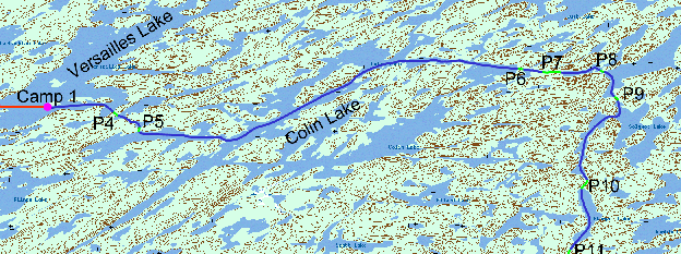
Day
2; Tuesday, August 13
We were up with the sun at 5.30 (which soon disappeared
behind a heavy overcast) and had bacon, eggs (egg whites) and coffee for
breakfast. We washed up, packed up, loaded and were on the water at 7.45. Being
on the water at 7:45 after a full breakfast with
just the two of us to pack the entire camp was very good. The
 It
was a short paddle to P4 (165 m) and P5 (120 m) then a long pull of about 12 km.
to the northwest on Colin Lake. Luckily, the northerly wind had abated. In
Gowrie Bay we passed two Indian motorboats going the other way, the crew muffled
against the cold while we were in T-shirts, then three canoes on Colin Lake
itself. There appears to be a good campsite on an island in Gowrie Bay and
another on the
‘vulture beak’ peninsula on Sandomirsky Island at GR 453835. After P6 (67 m,
poor condition), P7 started with 30 m of marsh followed by a long 406 m of
muskeg and deadfalls. Peter's shins suffered from scrambling over the spiky
spruce trunks. At 12.00 we were at P8, and portaged half the equipment,
then decided to return to the beginning for lunch as the wind there discouraged
the mosquitoes. After P8 we turned
south along the south end of Settee Lake to a 187 m but easy P9 which took us to
Solymos Lake. Here we were lucky that the wind had turned around to the north
and was at our backs. However, the temperature was falling, and there was a
heavy overcast with periods of light rain and no more sun.
Portage 10 (365 m) connects Solymos Lake with Stempel Lake. It is supposed to be in good condition, but both ends are very swampy, although the rest is easy.
We continued to run south on Stempel Lake to P11 (137 m),
which connects to the north end of Luther Lake, and is in fair condition
according to the guide. Peter went first with the food pack (still heavy!) and
Brent followed with the canoe (heavier). Peter diverted along a narrow, new trail
through the bush, but Brent continued on the old trail. The trail became
very
swampy but, with no foot prints showing, Brent decided Peter must
 Then
our troubles began.
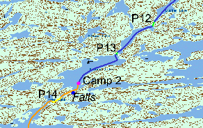
According to the guide P13:
Connects the south end of the small nameless lake with
the north end of Buchner Lake. Approximately 80 metres (87 yards) long and in
fair condition.
The start of the portage is in a small cove on the west shore of the small
nameless lake about 100 metres (109 yards) north of the outflowing stream (Grid
location 498751 - Map 73-P/9). A campsite is located at the Buchner Lake end of
the portage.
We took precise GPS readings but could not find the portage in the grid reference location, which had been burned. We looked all along the bank but could find no opening or trail. So we landed the canoe, unloaded the packs and struggled over the rocks and deadfalls with the canoe and one pack. As we came down to Buchner Lake we stumbled upon the end of a faint portage trail. We backtracked this trail to the beginning, which was just beside the outflowing stream, 100 metres off from the grid reference, and with the entrance screened by bushes and rocks. This was the first portage we had encountered without a confirming ribbon, although Ric later suggested that might have been because canoes were walked down the stream. We had a very difficult time retrieving the other four packs from where we had left them and struggling back through the dense bush to the new trail.
With the time taken on this portage, it was now time to camp. We were looking forward to camping at the site, noted in the guide, but this too had disappeared in the forest fire. We looked to the left of the stream, at the unburned area, but found nothing, and so were forced to continue south on Buchner, although prospects did not look good, as all the sides were all steep, at least 45°. We had to continue all the way down Buchner to near the south end, where the guide mentions waterfalls, and there we found a campsite on an island within the sound of the falls at GR 484731.
This
was a good thing because it