Day 2, Friday, 16
June
The sun was already high in the sky at 5 am. As
usual, Peter was up first at 6 am and made a fire and coffee. Jason emerged much
later after everyone else, confirming that he was not a morning person; he said he had never before been to bed
while it was still light outside. Breakfast
was coffee and bagels slathered with peanut butter.
We were surprised to see another party of two canoes with five
people pass our
campsite before we had finished breakfast.
They said they had arrived at the put-in about 8.30 the night before and
had paddled for half an hour before selecting their campsite.
It seems that everyone wants to save a few dollars by camping away from
the government sites. In spite of
this, they were up at 4 am the next day!
We were packed and on the water by 8:30 am.
The wind was now even stronger and, predictably, from the north, right in
our faces. We ground up Nemeiben Lake, seeking what lee we could.
We island hopped through North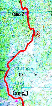 Bay, making short power runs across the
stretches of open water with white caps slopping against the canoes.
The canoes would climb over the first wave, and then crash into the
second one, stopping all forward progress.
A few strong paddle strokes would get the canoe going again, when the
process repeated itself. We powered
across to the north- west shore at the entrance to Bague Bay, and continued our
slog north-easterly. Finally, we
turned the corner and headed west and, with relief, arrived at the first
portage.
Bay, making short power runs across the
stretches of open water with white caps slopping against the canoes.
The canoes would climb over the first wave, and then crash into the
second one, stopping all forward progress.
A few strong paddle strokes would get the canoe going again, when the
process repeated itself. We powered
across to the north- west shore at the entrance to Bague Bay, and continued our
slog north-easterly. Finally, we
turned the corner and headed west and, with relief, arrived at the first
portage.
Portage Number 1: Connecting
Bague Bay with a small nameless lake, 305 metres long and in good condition, but
wet at the west end.
The portage was a wonderful stroll in the woods.
The wind meant almost no bugs and the trail was wide and dry.
Another two kilometers of paddling, still in the teeth of the north wind,
brought us to portage 2. For the
smaller lakes, we rotated the bowmen into the sterns.
A change of scenery for all, although the tracking tended to be more zig
zag.
Portage Number 2:
Connecting the small nameless lake with a beaver pond, 330 metres long and in
poor condition.
This portage trail was a soggy slog through the grass and mud, then a delicate
dance up a stream bed. At this
point, the trail was flooded out, so we dropped our canoes into the water.
Peter paddled/dragged the empty canoe 50 feet through the water, over a
beaver dam and into the waiting beaver pond.
The other canoes soon followed. The
gear was then man-handled over and between large boulders to the waiting canoes,
except for Brent who chose to wrestle his loaded canoe along the channel.
The beaver pond was only about 200 metres long so we were quickly at portage 3
Portage Number 3: Starts
from the end of an old man-made channel at the north end of the pond.
Connects the beaver pond along the shallow inflowing stream with a small
nameless lake. 460m metres long and in generally good condition, but steep in
spots and wet at the ends.
Another “man-made channel” made just getting to the portage trail tough.
The canoes were dragged along. Some
people, for example Brent, just waded through the smelly mud.
He stopped this when he almost had his sneakers sucked off. The rest of us hopped from hillock to rotten wood to hillock
to wood… Once on the trail, life
was easy, although the steep slope had everyone breathing hard. At the top, the early arrivers were treated to swarms of
black flies, which encouraged early departure.
Even once the canoes left the shore, the black flies hung on, buzzing in
the wind shadow of the paddlers. For
the most part, the black flies didn’t bite, but were irritating in the
extreme, by flying into your ears, eyes, nose and mouth.
If you ignored them, they would finally get their courage up, and slash
you to get some blood.
About a one km paddle brought us to portage 4.
Portage Number 4: This
portage starts at the end of a narrow man-made channel and connects the small
nameless lake with Little Crooked Lake. 45 metres long and in generally good
condition , but steep in spots and wet at the ends.
Yet another stinking, muddy “man-made channel”. We concluded that these were created by ski-doos running over
the portage trails in winter. The
little bits of red reflector debris at spots along the trails confirmed this. The wide and dry trail
went steeply uphill to the watershed, and then down on the other side.
Beginning to paddle Crooked Lake, we encountered the other canoe party again, already well
established in a campsite on the east shore.
They had made good time, but had a leisurely day or two ahead while
waiting for their rendezvous with a fly-in fishing party on Black Bear Island
Lake.
Now ready to paddle on, we looked around more carefully and became puzzled.
The pattern of lakes and islands did not match the features on our maps. In short, we were a little lost.
It turned out that the confusion arose because of an erroneously drawn
line on the second map. In reality,
we were one bay farther east than we expected to be. This was all resolved within half an hour, but by that time
we were ready to stop a little earlier than planned and set up camp on a
peninsula in the narrows at 7 pm.
Earlier in the day, we found that Peter's camera had not
rewound at the end of the film. When the case was opened the most recent
exposures were lost, including all of those of the first and second days.
The solution was postponed until camp that night when Warren disappeared into
the tent, inside black waterproofs inside a sleeping bag, plus various other coverings,
and succeeded in detaching the stuck film and winding it back into the
can. Another film was loaded and proved to work OK.
We had hamburgers for dinner, (for the second night in a row), but
we rationalized that we were burning 6000 calories a day.
The hamburgers were expertly grilled to everyone’s taste by Jason. Some
of the bigger eaters muttered some dissatisfaction with the quantity of food…
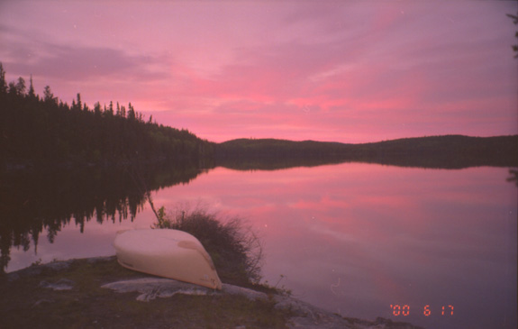
Sunset over Crooked Lake
[ Introduction ] [ Day 1 ] [ Day 2 ] [ Day 3 ] [ Day 4 ] [ Day 5 ]